%20(1).png)

Photo: Ryan Flett
The Issues
The proposed Record Ridge mine raises a number of concerns. Here are the key issues, at a glance.
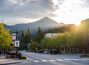
Proximity to Communities
The proposed mine site is located approximately 7 km from Rossland and even closer to the communities of Paterson and Big Sheep Creek. This would make it the closest open-pit mineral mine to a community in British Columbia.
The operation would include drilling and blasting, rock crushing, and hauling ore offsite.
These activities are expected to occur regularly, in the hottest and driest time of year, raising serious concerns about noise, dust, visual impact, and conflicting uses of the ridge for local communities and visitors.

Air Quality & Health
The magnesium at Record Ridge is found in serpentinite rock, which naturally contains asbestos*. Mining activities generate airborne dust.
Community concerns include:
-
asbestos and silica particles becoming airborne
-
dust travelling via prevailing winds into nearby communities
-
inadequate data collection to inform effects assessments; and
-
limited real-world modelling of how these particles will disperse to the surrounding communities.
*Asbestos mining is banned in Canada due to known health risks, however, asbestos can still co-exist with materials that are extracted, as is the case at Record Ridge.
.jpeg)
Sensitive Ecosystem
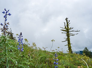
Record Ridge is part of a rare grassland ecosystem and has been identified as a Key Biodiversity Area.
The area supports red-listed plant communities and wildlife habitat, including species at risk such as the mountain holly fern.
The proposed mine footprint overlaps with this sensitive environment, raising concerns about habitat loss and long-term ecological impacts.

Water & Watershed
The proposed mine is located within the Columbia River watershed and near to local water systems, including Sophia Creek, which flows into downstream waterways. Water from Sophia Creek and the aquifer underlying the mine site is relied upon for domestic and agricultural water use. The mine would sit above an aquifer that underlies the communities of Paterson and Big Sheep Creek, from which scores of home draw their drinking water from the groundwater wells.
This local watershed is further part of the larger Columbia watershed where significant efforts are underway to restore salmon migration to the Upper Columbia River—an area where salmon populations were historically abundant but have been dramatically reduced over the past century due to human development.
Concerns have been raised regarding water contamination including:
-
impacts to local drinking water and other local water uses
-
sediment runoff and discharge into local creeks
-
airborne dust settling into water sources
-
potential leaching from waste rock

Recreation & Tourism
The proposed mine overlaps with well-used recreation areas and borders the south end section of the Seven Summits Trail—one of only four IMBA Epic trails in Canada (and one of only 35 globally).
The area is also used for backcountry skiing, hiking and trail running.
Recreation tourism has become the major economic driver in Rossland, the only Resort Muncipality in the West Kootenays, generating tens of millions annually and supporting hundreds of local jobs and businesses.
Concerns have been raised about:
-
rerouting or loss of the Seven Summits Trail and access
-
visual impacts to the landscape used by outdoor enthusiasts
-
noise and dust affecting the outdoor experience and human health
-
impacts to recreation and tourism at large, due to the proximity of open-pit mining activities to a developed resort municipality.

Environmental Review
The project has not undergo a full environmental assessment. In 2024, the Environmental Assessment Office determined the project required an environmental assessment, but changed its decision once the project's proposed production was reduced below the provincial mineral mine threshold for environmental assessment of 75,000 tonnes per year.
The project’s stated production has in fact been reduced multiple times from:
-
400,000 tonnes/year to
-
249,000 tonnes/year to
-
200,000 tonnes/year to
-
63,500 tonnes/year (which is 0.4% below the 15% threshold for notification and assessment)
Since amending its application from 200,000 tonnes/year to 63,500 tonnes/year, the overall footprint and infrastructure of the project have remained largely unchanged, and continue to support the former larger project.
Further, documents and public communications indicate ore production is anticipated to increase significantly once the pilot project would be completed. This has raised concerns about whether the project’s full impacts have been properly assessed.
Why This Matters
This project is already advancing through the permitting process.
Many residents, local organizations, and stakeholders are not opposed to development, but are calling for a full and transparent environmental assessment to better understand the potential impacts before the project proceeds.
At the center of this issue is a simple question: Has this project been fully and properly assessed to protect human health and the environment?